Manaslu Circuit Trek Distance: Quick Facts
|
Detail
|
Distance / Info
|
|
Total Trek Distance (standard route)
|
177 km (110 miles)
|
|
Total with Side Trips
|
190 to 195 km
|
|
Highest Point
|
Larkya La Pass, 5,106 m
|
|
Trek Duration
|
12 to 14 trekking days
|
|
Longest Single Day
|
22 km (Dharamsala to Bimthang via Larkya La)
|
|
Shortest Trekking Day
|
6 km (Samdo to Dharamsala)
|
|
Average Daily Distance
|
12 to 18 km
|
|
Road Distance (Kathmandu return)
|
335 km
|
|
Total Kathmandu-to-Kathmandu
|
Approximately 512 km
|
Daily Distance Breakdown by Day
Here is our standard 12-day trekking itinerary with distances, elevations, and walking hours from our GPS records across multiple seasons.
Day 1: Kathmandu to Machhakhola (930 m)
Drive via Dhading Besi and Arughat. Road distance: approximately 160 km. Driving time: 7 to 9 hours depending on conditions past Arughat. The road beyond Arughat is unpaved and rough, especially during or just after monsoon. No trekking this day.
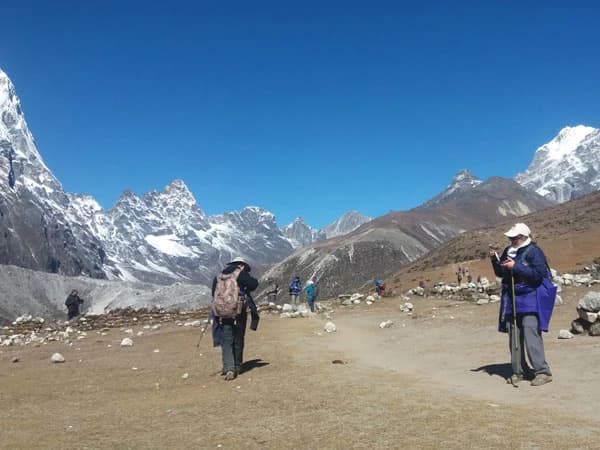
Day 2: Machhakhola to Jagat (1,340 m)
Distance: 15 km. Walking time: 6 to 7 hours.
The trail follows the Budhi Gandaki River through a narrow gorge. You cross several suspension bridges, pass through Khorlabesi, and hit the hot spring at Tatopani where most groups stop for 20 minutes. The path is rocky and undulating, with a few steep short climbs. After rain, rockfall debris covers parts of the trail between Khorlabesi and Jagat. Our porters walk behind the group in these sections.
Jagat is where your Restricted Area Permit gets checked for the first time at the police checkpoint.
Day 3: Jagat to Deng (1,860 m)
Distance: 20 km. Walking time: 7 to 8 hours.
This is the longest day by distance. The trail climbs steadily through bamboo forests, past waterfalls, and through a gorge so tight you can hear the river echo off both walls. You pass through Salleri and Sirdibas before dropping into Philim, a Gurung village where we usually stop for lunch. The final section into Deng crosses a long suspension bridge over the Budhi Gandaki.
Day 4: Deng to Namrung (2,630 m)
Distance: 19 km. Walking time: 7 to 8 hours.
Another long day, but the valley opens up and the scenery changes. You leave the subtropical gorge behind and enter a landscape of stone-walled fields, mani walls, and prayer flags. The trail passes through Ghap, where a carved stone gate marks the transition into the Tibetan Buddhist cultural zone. Namrung has a small monastery and a few teahouses with basic rooms.
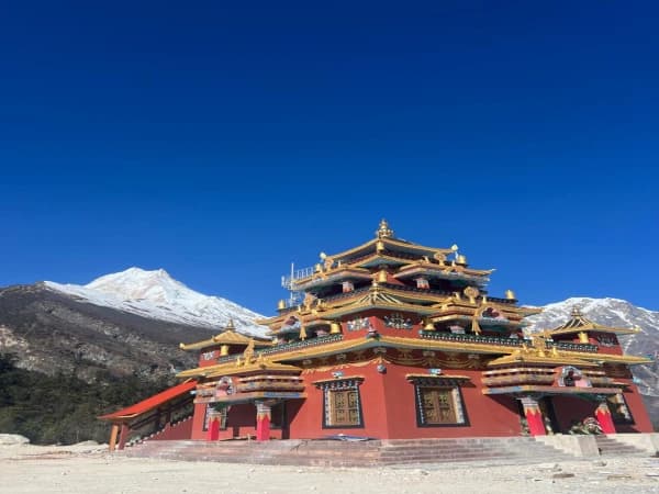
Day 5: Namrung to Lho (3,180 m)
Distance: 11 km. Walking time: 4 to 5 hours.
A shorter day, and the first real reward. Lho offers a direct, unobstructed view of Mt. Manaslu (8,163 m) and Manaslu North (7,157 m) that fills the entire valley ahead of you. Ribung Monastery is a 45-minute walk above the village. You pass the longest mani wall on the circuit between Namrung and Lho, stretching over 200 meters along the trail.
Day 6: Lho to Samagaun (3,530 m)
Distance: 8 km. Walking time: 3 to 4 hours.
An easy day through Shyala village with views of Himalchuli (7,893 m) and Ngadi Chuli (7,871 m). Samagaun is the largest settlement on the circuit. It has a school, a health post, a few shops selling biscuits and instant noodles at inflated prices, and a gompa perched on the hill above town. The teahouses here have attached bathrooms, which is the last time you will see that until Bimthang.
Day 7: Acclimatization Day at Samagaun
No trekking required. Two side trip options:
Option A: Birendra Lake (3,650 m). About 3 km round trip, 1.5 to 2 hours. A glacial lake below the Manaslu Glacier. Easy walk, good for a rest day.
Option B: Manaslu Base Camp (4,800 m). Roughly 10 to 12 km round trip, 6 to 8 hours. A full day hike up the moraine. Worth it for the close-up view of Manaslu's south face. Our guide Bashu Sherpa usually recommends this for groups that handled the altitude well coming into Samagaun.
This acclimatization day adds 3 to 12 km to your total depending on which option you choose. Do not skip it.
Day 8: Samagaun to Samdo (3,875 m)
Distance: 7 km. Walking time: 3 to 4 hours.
Short and relatively flat along the river valley. Yak herders use this trail, and you will likely share it with yak caravans carrying supplies between Samdo and Samagaun. Give yaks the right of way and stand on the uphill side when they pass. Samdo is a small settlement with Tibetan refugee families. The teahouses are basic, and water pipes freeze overnight from November onward.
Day 9: Samdo to Dharamsala / Larkya Phedi (4,460 m)
Distance: 6 km. Walking time: 3 to 4 hours.
The shortest trekking day, deliberately. Dharamsala is a single stone shelter with a tin roof, no attached bathrooms, and no hot water. The wind picks up hard after 2 PM, and temperatures drop fast once the sun goes behind the ridge. Eat dinner early, fill your water bottles before the pipes freeze, and get into your sleeping bag by 7 PM. Our groups carry an extra thermal blanket for this night because the teahouse blankets are thin.
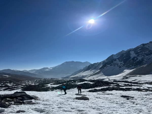
Day 10: Dharamsala to Bimthang (3,590 m) via Larkya La Pass (5,106 m)
Distance: 22 km. Walking time: 8 to 10 hours.
The hardest and longest day. We wake the group at 3:30 AM. Breakfast is instant noodles and hot tea because the kitchen is barely functional. You start climbing by 4:00 AM with headlamps.
The climb to the pass takes about 5 hours over moraine and snow. Above 4,800 m, the trail is marked by cairns, and in fresh snow, our guide breaks trail ahead of the group. At the pass (5,106 m), you can see Himlung (7,126 m), Kang Guru (6,981 m), and Annapurna II (7,937 m) to the west. The descent to Bimthang is steep, loose, and hard on the knees. Trekking poles are not optional. Groups that leave after 5 AM risk crossing the pass in afternoon wind, which can turn dangerous.
Day 11: Bimthang to Tilije (2,300 m)
Distance: 17 km. Walking time: 6 to 7 hours.
Mostly downhill through rhododendron and pine forest. You cross the Dudh Khola river and the landscape shifts from alpine to farmland. Tilije has several guesthouses and a warm atmosphere after the cold of the higher trail.
Day 12: Tilije to Dharapani (1,860 m), Drive to Kathmandu
Distance: 6 km trek to Dharapani. Walking time: 2 hours.
At Dharapani, you join the road that connects to the Annapurna Circuit. A jeep takes you to Besisahar (about 54 km), then the long drive back to Kathmandu (175 km). Total driving: 8 to 9 hours.
How Side Trips Change Your Total Distance
The 177 km figure covers only the standard trail from Machhakhola to Dharapani. Several worthwhile detours add to that total.
Manaslu Base Camp from Samagaun: 10 to 12 km round trip. The most popular side trip on the circuit. The hike follows the Manaslu Glacier moraine to 4,800 m.
Pungyen Gompa from Samagaun: About 8 km round trip. A high viewpoint with panoramic views of Manaslu, Ngadi Chuli, and the entire Nubri valley.
Birendra Lake from Samagaun: 3 km round trip. A shorter, easier option for acclimatization.
Tsum Valley Extension: Adds 38 to 55 km and 5 to 7 extra days. The Tsum Valley branches off the main circuit at Lokpa and takes you into a culturally distinct valley with ancient monasteries and farming villages near the Tibetan border. A separate Tsum Valley Permit is required (USD 35 to 40 depending on season, as of May 2026).
With the Manaslu Base Camp side trip alone, expect a total of approximately 189 km. With both the base camp and Pungyen Gompa, you approach 195 km. Add Tsum Valley and the circuit becomes 215 to 250 km over 17 to 19 days.
Manaslu Circuit vs. Everest Base Camp vs. Annapurna Circuit: Distance Comparison
|
Trek
|
Total Walking Distance
|
Duration
|
Highest Point
|
|
Manaslu Circuit
|
177 km
|
12 to 14 days
|
Larkya La, 5,106 m
|
|
Everest Base Camp (round trip from Lukla)
|
130 km
|
12 to 14 days
|
Kala Patthar, 5,555 m
|
|
Annapurna Circuit (Besisahar to Jomsom)
|
160 to 230 km
|
12 to 21 days
|
Thorong La, 5,416 m
|
The Manaslu Circuit is longer than EBC but shorter than a full Annapurna Circuit. What makes the Manaslu Circuit harder than its raw distance suggests is the remoteness. Teahouses above Samagaun are fewer and more basic than anything on the EBC or Annapurna trails. Between Samdo and Bimthang, there is essentially one place to sleep (Dharamsala). If the weather closes Larkya La, you wait. There is no alternative route or helicopter pad nearby.
The Hardest Section: Dharamsala to Bimthang
The Larkya La crossing is the crux of the entire trek. At 22 km with a pre-dawn start, a 650 m climb to the pass, and a 1,500 m descent to Bimthang, it is the longest and most demanding day by any measure.
So what does this section actually look like?
The first two hours are a gradual climb over frozen ground and loose rock. By the time you reach the base of the pass wall, it is still dark or barely dawn. The final push to 5,106 m takes another 2 to 3 hours and crosses snowfields that can be slippery without gaiters and trekking poles. In late November, we have seen knee-deep snow on the north side of the pass.
At the top, you get maybe 20 to 30 minutes to rest and take photos before the wind makes standing uncomfortable. The descent to Bimthang is steep, with a loose scree that moves underfoot. Your knees will feel the 1,500 m drop. Most trekkers arrive in Bimthang exhausted, eat dal bhat, and sleep by 7 PM.
What Affects Your Walking Speed on the Trail
How many kilometers per day can you actually cover on the Manaslu Circuit? That depends on three things.
Altitude. Above 3,500 m, every hundred meters of elevation gain slows you down. A 15 km day at Jagat (1,340 m) takes about 5 to 6 hours. That same distance near Dharamsala (4,460 m) can take 7 to 8 hours. You are breathing harder, moving slower, and stopping more often.
Trail condition. The gorge sections between Machhakhola and Deng are narrow and rocky, with landslide debris after monsoon. New bridges and trail reroutes happen every season. On our October 2025 departure, a fresh landslide between Jagat and Salleri added 45 minutes to the day.
Pack weight. We include a porter for every two trekkers in our Manaslu package. If you carry your own gear (10 to 12 kg), you will walk slower and feel more strain on the long descent from Larkya La. A lighter daypack (3 to 5 kg with water, rain layer, snacks, and camera) makes a real difference over 177 km.
Best Time to Trek the Manaslu Circuit
October to mid-November is the strongest window. Clear skies, stable temperatures, and Larkya La is almost always open. October sees the most trekkers, but "busy" on the Manaslu Circuit means 10 to 15 others at a teahouse. Compare that to 50+ at Gorak Shep on the EBC trail in the same month.
Late March to May is the second-best window. Warmer in the lower sections, rhododendrons blooming between Bimthang and Tilije, and fewer trekkers. April afternoons can bring clouds that block mountain views. Larkya La occasionally gets late-season snowfall, and we send a guide ahead to check pass conditions before committing the group.
Early December and early March are risky. Heavy snow on Larkya La, extreme cold at Dharamsala (below -15C at night), and some teahouses close for winter. Only attempt this with high-altitude experience and proper gear.
June to August (monsoon): Rain, leeches below 2,500 m, landslides between Machhakhola and Jagat. We do not operate Manaslu treks during monsoon.
Common Mistakes on the Manaslu Circuit
Skipping acclimatization at Samagaun. This is the single biggest mistake we see. Trekkers who push straight through from Samagaun (3,530 m) to Samdo to Dharamsala without resting get altitude sickness symptoms at the worst possible time, just before the highest pass. We have arranged emergency helicopter evacuations from Dharamsala for trekkers on other agencies' itineraries who skipped this rest day.
Starting the Larkya La day too late. Groups that leave Dharamsala after 5 AM risk crossing the pass in afternoon wind. Our groups aim to be at the pass by 8:30 AM.
Not carrying enough cash. There are no ATMs on the Manaslu Circuit. The last ATM is in Kathmandu. Carry NPR 30,000 to 40,000 in cash for personal expenses like hot showers (NPR 300 to 500), device charging (NPR 200 to 400 per hour), and extra snacks.
Packing too much. You do not need three jackets. One down jacket, one fleece, one waterproof shell. At our pre-trek briefing at Paknajol, Amrit Khadka goes through every trekker's bag and flags what to leave at the hotel in Kathmandu.
Permit Costs for the Manaslu Circuit (as of May 2026)
|
Permit
|
Cost (Foreign Nationals)
|
Notes
|
|
Manaslu Restricted Area Permit (RAP)
|
USD 100 / first 7 days (Sept to Nov), USD 75 / first 7 days (Dec to Aug)
|
Additional days: USD 15 (autumn) or USD 10 (other seasons)
|
|
Manaslu Conservation Area Permit (MCAP)
|
NPR 3,000 (approx. USD 22)
|
Issued by Nepal Tourism Board
|
|
Annapurna Conservation Area Permit (ACAP)
|
NPR 3,000 (approx. USD 22)
|
Required for Dharapani to Besisahar section
|
|
Chumnubri Rural Municipality Entry Fee
|
NPR 1,000 (approx. USD 7.50)
|
Collected at Jagat checkpoint
|
Permit fees verified against Department of Immigration and Nepal Tourism Board schedules as of May 2026. A licensed guide is mandatory and enforced at checkpoints. As of March 2026, registered agencies can process individual RAP applications for solo trekkers with a licensed guide.
We handle all permit processing for our groups. We need your passport scan and two photos at least two weeks before your trek start date.
FAQ
How long is the Manaslu Circuit Trek in kilometers?
The Manaslu Circuit Trek is approximately 177 km (110 miles) on the standard route from Machhakhola (930 m) to Dharapani (1,860 m). With side trips to Manaslu Base Camp and Pungyen Gompa, the total extends to 190 to 195 km.
How many miles is the Manaslu Circuit Trek?
The standard route is about 110 miles. With common side trips, it increases to 118 to 121 miles. These figures cover trekking distance only, not the 335 km of road travel between Kathmandu and the trailhead.
How many km per day do you walk on the Manaslu Circuit?
Daily trekking distances range from 6 km to 22 km. Average across the full trek is 12 to 18 km per day. The longest day is the Larkya La Pass crossing at 22 km. Acclimatization and high-altitude days are deliberately shorter, between 6 and 8 km.
How difficult is the Manaslu Circuit Trek?
The Manaslu Circuit is rated as challenging. The combination of 177 km of walking, a 5,106 m pass crossing, remote teahouse infrastructure, and 8 to 10 hour walking days at altitude makes it harder than EBC despite a slightly lower maximum elevation. Previous trekking experience above 4,000 m is strongly recommended.
Can beginners do the Manaslu Circuit Trek?
Beginners with strong cardiovascular fitness and proper preparation can complete the Manaslu Circuit, but this is not an entry-level trek. If you have never trekked above 3,000 m, we recommend the Ghorepani Poon Hill Trek or Langtang Valley Trek first to gauge your body's altitude response.
Why do different websites show different distances for the Manaslu Circuit?
Starting point matters. Starting from Soti Khola adds 13 to 15 km. Starting from Arughat adds another 20 km on top of that. Side trips and the Tsum Valley extension add 10 to 55 km more. Trail reroutes due to landslides also shift the total by a kilometer or two each season. Most modern itineraries start from Machhakhola, which gives the standard 177 km figure.
What permits do I need for the Manaslu Circuit Trek?
You need the Manaslu Restricted Area Permit (RAP), Manaslu Conservation Area Permit (MCAP), Annapurna Conservation Area Permit (ACAP), and the Chumnubri Rural Municipality Entry Fee. All permits must be arranged through a registered trekking agency. TIMS cards are not required for the Manaslu Circuit as of 2026.
Planning the Manaslu Circuit for 2026?
We run guided departures every spring and autumn with experienced local guides, porter support, full permit handling, and acclimatization-focused itineraries built from 13 years of operating this route.
See our full 12-day Manaslu Circuit Trek itinerary and pricing for a day-by-day schedule, gear list, and what is included.
For questions about the route, fitness requirements, or custom itineraries:
WhatsApp: +977 9851363944
Email: [email protected] Office: Paknajol 16, Thamel, Kathmandu