Trip at a Glance
|
Detail
|
Information
|
|
Duration
|
12 Days
|
|
Highest Point
|
Larkya La Pass, 5,160m
|
|
Start / End
|
Machha Khola / Dharapani
|
|
Difficulty
|
Strenuous (Grade 4 of 5)
|
|
Best Months
|
March-May, September-November
|
|
Style
|
Tea house (lodge-based)
|
|
Permits
|
Restricted Area + MCAP + ACAP
|
|
Guide
|
Mandatory by law
|
|
Min. Group Size
|
1 trekker (solo permits allowed since March 2026)
|
|
Highest Sleep
|
Dharmasala, 4,460m
|
|
Group Size
|
2-10 per departure
|
|
Meals
|
All included
|
Quick Answer
The Manaslu Circuit is Nepal's best restricted area trek for experienced hikers who want genuine remoteness, Tibetan Buddhist culture, and a serious pass crossing without Annapurna or Everest crowds. You need a restricted area permit (we process it) and a licensed guide (mandatory). Since March 2026, solo trekkers can obtain the restricted area permit individually, so you no longer need a second person on the permit. The 12-day route includes 2 acclimatization days and crosses Larkya La at 5,160m on Day 10. Not suitable for complete beginners.
Why Trekkers Book With Regal Nepal Treks
We are a Kathmandu-based operator, not a booking platform. Your guide works for us directly. We process your restricted area permit through the Department of Tourism ourselves.
Registered with the Nepal Tourism Board since 2015. Guides with 15+ Manaslu Circuit completions across all seasons. Full permit handling including restricted area paperwork. Emergency evacuation coordination with helicopter contacts. Small groups (max 10 trekkers per departure). Fair wages and insurance for all porters. 24/7 Kathmandu office support during your trek. Direct operator pricing, no middleman.
Our guide Pemba, after 60+ Larkya La crossings: "Every crossing is different. The mountain does not care about your schedule. We go when conditions are right, we stop when they are not. That is why people come home safe with us."
What Is the Manaslu Circuit Trek?
The Manaslu Circuit is a loop trek in the Manaslu Conservation Area of central-western Nepal. It starts with a long drive from Kathmandu to Machha Khola, then follows the Budhi Gandaki River north into increasingly remote terrain. The first few days pass through subtropical forest and terraced farmland. By Day 5, you are in the rain shadow of the Himalaya, walking through dry valleys that look more like Tibet than Nepal.
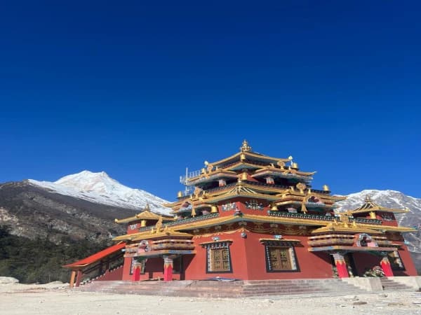
The cultural shift is noticeable. Below Namrung, villages are predominantly Hindu and ethnically Gurung. Above Namrung, the settlements are Tibetan Buddhist. Samagaon has a monastery with resident monks. Prayer wheels line the trails. Mani walls (stone slabs carved with Buddhist mantras) appear at every village entrance. You walk past them on the left, always.
The physical crux is the Larkya La Pass crossing on Day 10. At 5,160m, it is roughly the same elevation as Everest Base Camp but feels harder because of the long approach from Dharmasala and the steep descent into Bimthang. The day starts between 3:00 and 4:00 AM and takes 8 to 10 hours.
After the pass, the trail drops into the Marshyangdi Valley, connecting with the lower Annapurna Circuit route near Dharapani. From there, a jeep takes you back to Kathmandu.
Why Choose This Trek Over Annapurna or Everest?
Fewer people. Manaslu recorded roughly 12,500 trekkers in the 2024-25 season, an all-time high but still a fraction of the main circuits. Annapurna routes see over 250,000 trekkers per year. Everest Base Camp gets about 50,000. On the Manaslu trail, you still walk for hours without meeting another group, though the gap is narrowing as the route gains popularity.
Deeper cultural immersion. Tourism arrived late here. Villages have not been reshaped around trekker expectations. You eat what locals eat. Tea houses are family run.
Genuine exclusivity. The restricted area permit requirement and mandatory licensed guide filter out casual hikers. The new solo permit rule (March 2026) makes access easier for independent trekkers, but the logistical requirements still keep numbers far below open trails like Annapurna. More on this in our Nepal trekking permits guide.
Terrain variety. In 12 days: subtropical forest, bamboo groves, alpine meadows, glacial moraines, and a high-altitude desert valley. Few treks anywhere offer that range.
High-altitude challenge at a lower cost. Larkya La at 5,160m tests your fitness and gear. The total cost is significantly less than an Everest Base Camp package.
Comparison Table
|
Factor
|
Manaslu Circuit
|
Annapurna Circuit
|
Everest Base Camp
|
|
Trekkers/year
|
~12,500
|
~250,000
|
~50,000
|
|
Guide required
|
Yes
|
No (recommended)
|
No (recommended)
|
|
Restricted permit
|
Yes
|
No
|
No
|
|
Tea house quality
|
Basic
|
Good-excellent
|
Good-excellent
|
|
WiFi
|
Unreliable above Namrung
|
Most places
|
Most places
|
|
Cultural feel
|
Tibetan Buddhist
|
Mixed Hindu-Buddhist
|
Sherpa Buddhist
|
|
Highest point
|
5,160m
|
5,416m
|
5,364m
|
|
Trail traffic
|
Low
|
High
|
High
|
|
Cost range
|
$$
|
$
|
$$$
|
Manaslu tea houses are not at the same standard as Annapurna or Everest. Rooms are smaller, menus more limited, charging scarce. If you want comfort, this is not the right trek. If you want an authentic Himalayan experience with few other trekkers, it is exactly right. For help deciding, see our guide to choosing the right Nepal trek.
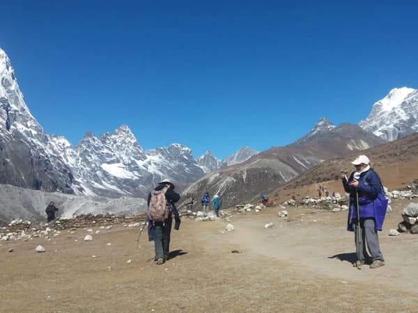
Trek Highlights
The narrow Budhi Gandaki gorge: suspension bridges, waterfalls, canyon walls. Entering the Tibetan cultural zone above Namrung. Two nights in Samagaon (3,530m) with direct views of Manaslu's north face. Pungen Gompa monastery near Samagaon. The high-altitude village of Samdo (3,860m), one of the last settlements before Larkya La. Larkya La Pass (5,160m): 360-degree views of Manaslu, Himlung Himal, Cheo Himal, and Annapurna II. The alpine meadow of Bimthang (3,590m). Optional side trip to Manaslu Base Camp (4,400m) on the acclimatization day.
12-Day Itinerary
Day 01: Kathmandu to Machha Khola (870m)
Drive: 8-9 hours (private jeep or local bus) | Walking: 0-1 hour from drop-off | Difficulty: Easy (travel day)
You leave Kathmandu early, typically by 6:00 AM. The drive follows the Prithvi Highway west toward Dhading Besi. This section is paved and reasonably comfortable. After Dhading Besi, the road turns north and deteriorates quickly into rough, unpaved track. The final section to Machha Khola is bumpy and slow, especially during or after rain when the dirt road turns to mud.
Machha Khola is a small riverside settlement along the Budhi Gandaki River at just 870m elevation. The heat and humidity are noticeable. Tea houses here are simple but adequate: twin beds, thin foam mattresses, shared bathrooms. Expect dal bhat for dinner. The evening is warm at this altitude, and you will hear the river rushing all night.
Practical tip: Eat a solid breakfast in Kathmandu before departure. Roadside food stops along the drive are unpredictable in quality and timing. Bring snacks and a water bottle for the vehicle. Motion sickness tablets can help on the rough road sections.
Day 02: Machha Khola to Jagat (1,340m)
Elevation Gain: ~470m | Walking: 6-7 hours | Trail: River valley, suspension bridges, rocky path | Difficulty: Moderate
The trail follows the Budhi Gandaki upstream through a narrowing gorge. You cross the river multiple times on suspension bridges, some of which sway considerably under weight. The gorge narrows in places, and the path is carved into steep rock with some exposed sections. There are a few short but steep climbs and descents where the trail navigates around cliff faces.
The vegetation is subtropical: bamboo, banana trees, and sal forest. It is hot and humid, especially between 10:00 AM and 2:00 PM. Carry at least 2 liters of water and use sunscreen even though the trail is partially shaded.
Jagat is a small bazaar village that marks the entrance to the Manaslu Conservation Area. Your permits are checked here at the first official checkpoint. Tea houses are basic but have more options than Machha Khola. You can buy snacks and basic supplies.
Food note: Dal bhat is the most reliable and filling option at this altitude. Noodle soups (thukpa) are also available at most stops. Avoid ordering meat below 2,000m if refrigeration looks questionable.
Day 03: Jagat to Deng (1,860m)
Elevation Gain: ~520m | Walking: 6-7 hours | Trail: Deep gorge, river crossings, steep sections | Difficulty: Moderate
The gorge deepens. The trail climbs and drops repeatedly around cliff faces. Some sections rebuilt after landslides feel exposed but are manageable with basic care. You pass through Salleri and Philim for lunch.
Deng sits at the confluence of the Budhi Gandaki and Deng Khola. Limited tea houses (2-3 guesthouses). Hot showers depend on the solar heater.
Guide's note: Mobile phone signal becomes unreliable from Deng onward. Plan your last communications accordingly.
Day 04: Deng to Namrung (2,660m)
Elevation Gain: ~800m | Walking: 6-7 hours | Trail: Forest, gradual climb | Difficulty: Moderate-strenuous
The altitude gain starts to register today. The trail climbs through rhododendron and pine forest. You pass through Rana and Bihi, where stone houses with flat roofs replace thatched structures. The cultural transition is visible.
Namrung (2,660m) is the first distinctly Tibetan village. Prayer flags across rooftops, a small monastery above the settlement, cooler air, mountains appearing above the treeline.
Altitude note: Some trekkers notice mild headaches or shortness of breath here. Normal at this stage. Drink at least 3 liters today. Phone charging available (NPR 200-500). WiFi slow and unreliable.
Day 05: Namrung to Sama Gaon (3,530m)
Elevation Gain: ~870m | Walking: 6-7 hours | Trail: Open valley, mani walls | Difficulty: Strenuous
The Budhi Gandaki Valley widens considerably today. You pass through Lihi and Sho, Tibetan-style villages with carved mani walls at their entrances and prayer wheels lining the path. Forest thins out to juniper and birch. Views of Manaslu and Peak 29 (Ngadi Chuli) dominate the northern skyline as you gain elevation.
Samagaon (also written Sama Gaon) is the largest settlement on the circuit: about 1,500 people, a school, a small health post, and the significant Pungen Gompa monastery. The village sits in a wide glacial valley with Manaslu's north face directly visible. On clear mornings, the mountain reflects in a small lake near the village edge.
You spend two nights here for acclimatization. Tea houses in Samagaon are the best on the route, with menus including fried rice, egg dishes, noodle soups, pizza, and sometimes yak cheese or Tibetan bread. Samagaon now has a bakery serving apple pie, cinnamon rolls, and other baked goods, a welcome treat after days of dal bhat. Internet cafes are also available, though connections remain slow. Bottled water and snacks are available but expensive (NPR 300-500 for a 1-liter bottle). This is your last chance to buy supplies at reasonable variety.
The altitude is real at 3,530m. Walk slowly on the final approach into the village. Do not rush the last hour. Headaches are common on the first evening here. Drink at least 3 liters of water and avoid heavy exertion after arrival.
Day 06: Acclimatization at Sama Gaon (3,530m)
Optional hike: 3-5 hours | Difficulty: Moderate
This rest day is not optional. It is the single most important day for your success on Larkya La.
Recommended: Hike toward Manaslu Base Camp (4,400m). You do not need to reach it. Walking to 4,000-4,200m and returning is sufficient. Round trip: 3-5 hours. Alternative: visit Pungen Gompa, 30 minutes uphill from the village center.
What happens if you skip this day: Risk of altitude sickness on Larkya La increases sharply. We have seen trekkers who skipped the rest day struggle at Dharmasala and fail to cross the pass. More on altitude management in our altitude sickness guide.
Use the day to wash clothes, charge devices, and buy snacks. Samagaon is the last place with reasonable supplies.
Day 07: Sama Gaon to Samdo (3,860m)
Elevation Gain: ~330m | Walking: 3-4 hours | Trail: Wide valley, dry terrain | Difficulty: Moderate
A shorter day by design. The landscape becomes barren: juniper and brown grass replacing forest. Samdo is a small village of about 40 houses, historically a trading post with Tibet. The border is a few hours' walk north.
Afternoon wind can be fierce. Nighttime lows: minus 5 to minus 10C in peak season. Bring your sleeping bag rated to minus 15C. Charging: NPR 300-500/device. No reliable WiFi.
Day 08: Acclimatization at Samdo (3,860m)
Optional exploration: 2-4 hours | Difficulty: Easy-moderate
Your second rest day. Walk toward the Tibetan border viewpoint, hike the ridge east of the village, or rest and hydrate.
Critical: Some trekkers feel fine at 3,860m and assume they are ready for 5,160m. They are not. Continue drinking 3-4 liters per day. No alcohol. Report any persistent headache, nausea, or dizziness to your guide immediately.
Evening: Your guide briefs you on the next two days. Pack your daypack for the pass tonight. You need warm layers, rain gear, headlamp, water, and snacks accessible at all times. Your main bag goes with the porter.
Day 09: Samdo to Dharmasala (4,460m)
Elevation Gain: ~600m | Walking: 3-4 hours | Trail: Rocky moraine, exposed terrain | Difficulty: Strenuous (altitude)
Short in distance but demanding because of the altitude. The trail climbs out of Samdo through rocky, windswept terrain with no shelter from the wind. There is no village, no tea shop, nothing between Samdo and Dharmasala. The landscape is glacier moraine, loose rock, and sparse vegetation. You are well above the tree line.
Dharmasala (also called Larkya Phedi, meaning "foot of the pass") is not a proper settlement. It is a cluster of stone shelters with tin roofs at 4,460m, built specifically as a staging point for the pass crossing. Rooms are dormitory-style with thin mattresses on platforms. The kitchen serves simple food: dal bhat, noodles, hot drinks. Do not expect variety, quality, or warmth.
What it feels like: Cold. Even in October, the best trekking month, nighttime temperatures drop to minus 10 to minus 15 degrees Celsius. Wind cuts through the stone walls. Sleep comes in fragments because your body is adjusting to the altitude, and your breathing pattern changes. You will be wearing your down jacket inside your sleeping bag. Most trekkers sleep poorly here, and this is completely normal.
Why we stop here instead of pushing to the pass: Attempting Larkya La from Samdo in a single day adds dangerous altitude exposure. The 600m climb from Samdo to Dharmasala plus the additional 700m to the pass in one day is too much for safe acclimatization. Sleeping at 4,460m gives your body a critical final adjustment. Every responsible operator stops at Dharmasala.
Eat everything offered to you. You need the calories for tomorrow. Drink as much hot water and tea as you can stomach. Dehydration at altitude worsens AMS symptoms.
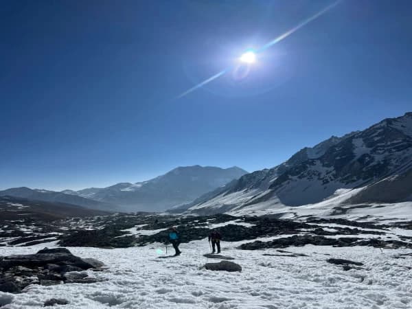
Day 10: Dharmasala to Bimthang (3,590m) via Larkya La Pass (5,160m)
Gain: ~700m to pass | Loss: ~1,570m to Bimthang | Walking: 8-10 hours | Difficulty: Very strenuous (hardest day)
This is the day that defines the Manaslu Circuit.
2:30-3:00 AM wake-up. Quick breakfast: porridge, tea, biscuits. Nobody eats much. Headlamps on. You step out into freezing darkness.
The climb: The first 2-3 hours are a steady climb up the moraine in darkness, following cairns and prayer flags. The trail is rocky with loose sections. Footing is tricky when frost-covered, and fresh snow makes it harder. Your guide leads, setting the pace. The trick is going slowly enough that you still have energy for the final push above 4,900m.
At the pass (5,160m): Arrival around 7:00-9:00 AM depending on conditions and group speed. Larkya La is a broad saddle marked with prayer flags and cairns. On a clear morning, the panorama is extraordinary: Manaslu (8,163m), Himlung Himal (7,126m), Cheo Himal (6,820m), Annapurna II (7,937m), and the Kanguru range spread across the horizon. You will not linger long. Temperature with wind chill can be minus 20C or colder, and afternoon clouds build fast at this altitude.
The descent: This is where the day gets truly demanding. The western side of Larkya La drops through loose scree and snow patches. The trail is steep and unstable underfoot. You descend for hours before reaching the glacier moraine, then cross into the gentler terrain leading to Bimthang's alpine meadow. Trekking poles are essential. Take short, deliberate steps.
Bimthang (3,590m): A wide, flat meadow surrounded by peaks. Tea houses here are basic but feel luxurious after Dharmasala. Hot food, relative warmth, and the relief of having crossed the pass make this evening one of the best on the entire trek. Your legs will ache. You will not care.
Day 11: Bimthang to Dharapani (1,860m)
Elevation Loss: ~1,730m | Walking: 6-7 hours | Trail: Forest, steep descent | Difficulty: Moderate
Long downhill through changing landscapes: alpine zone to rhododendron forest to subtropical belt. The trail passes through Tilije and Tal on the Annapurna Circuit route. You will see other trekkers for the first time in days.
Dharapani has better tea houses: hot showers, varied menus, working WiFi. Use trekking poles on the descent. Your knees will thank you.
Day 12: Dharapani to Kathmandu
Drive: 8-10 hours | Difficulty: Easy (travel day)
Jeep from Dharapani along the Marshyangdi Valley to Besisahar (rough road), then main highway to Kathmandu. Arrive late afternoon or evening.
We can arrange an overnight in Besisahar if you prefer to split the drive.
How Difficult Is the Manaslu Circuit Trek?
This route is harder than the Annapurna Circuit and comparable to Everest Base Camp, with the added challenge of a high pass crossing.
Physical: 5-8 hours of walking per day for 10 consecutive days. Cumulative elevation gain over 8,000m. The Larkya La day: 8-10 hours with a 700m climb and 1,570m descent.
Altitude: Six nights above 3,500m. Highest sleep at 4,460m. Pass at 5,160m. Acute mountain sickness is a real risk.
Terrain: Rough trail in the lower gorge (landslide zones, exposed crossings), loose scree on the pass approach, steep rocky descents.
Mental: Remoteness, basic food, cold nights, no bail-out options. You cannot quit halfway and catch a bus.
Difficulty Comparison
|
Trek
|
Grade
|
Highest Point
|
Pass Crossing
|
|
Manaslu Circuit
|
4 (Strenuous)
|
5,160m
|
Yes
|
|
Annapurna Circuit
|
3-4
|
5,416m
|
Yes
|
|
Everest Base Camp
|
3-4
|
5,364m
|
No
|
|
Langtang Valley
|
2-3
|
3,870m
|
No
|
Who Should and Should Not Trek Manaslu?
Suitable For
Trekkers with at least one 5+ day trek completed. People who can walk 6-8 hours daily with a daypack for 10 consecutive days. Anyone comfortable with basic lodging and limited menus. Trekkers genuinely interested in remote Himalayan culture.
Not Suitable For
Complete beginners (consider Langtang Valley or Annapurna Base Camp first). Anyone with unmanaged heart, lung, or blood pressure conditions. Trekkers who need daily WiFi or phone connectivity. People who expect hotel-standard accommodation.
How Does Acclimatization Work on This Route?
Our itinerary includes two dedicated rest days following the "climb high, sleep low" principle:
|
Day
|
Acclimatization Plan
|
|
Day 5
|
Arrive Samagaon (3,530m)
|
|
Day 6
|
Hike to ~4,200m, sleep at 3,530m
|
|
Day 7
|
Walk to Samdo (3,860m)
|
|
Day 8
|
Rest or hike to ~4,200m, sleep at 3,860m
|
|
Day 9
|
Sleep at Dharmasala (4,460m)
|
|
Day 10
|
Cross Larkya La (5,160m), descend to Bimthang (3,590m)
|
Five days above 3,500m before the pass, including 2 rest days. With proper compliance, our pass completion rate is near 100%. Those who skip rest days or push too fast account for most turnarounds.
Is Altitude Sickness a Real Risk on Manaslu?
Yes. AMS is not about fitness. Fit, young trekkers get it as often as older ones. It depends on individual physiology and acclimatization speed.
Where symptoms typically appear: Samagaon (3,530m) or Samdo (3,860m). Mild headache, reduced appetite, disrupted sleep. Usually manageable.
Where it becomes serious: Dharmasala (4,460m). If symptoms worsen here (loss of balance, persistent vomiting, confusion, wet cough), the trekker descends immediately. Our guides carry pulse oximeters and monitor all trekkers.
Diamox: Helps acclimatization but has side effects (tingling, increased urination, altered taste). Consult your doctor before the trek. We do not prescribe, but our guides recognize AMS signs and will enforce descent when necessary.
How Hard Is the Larkya La Pass Crossing?
Larkya La (5,160m) is the crux of the circuit.
Best window: Early morning, 7:00-9:00 AM. Afternoon weather is unreliable.
Trail: Moraine and loose rock from Dharmasala. Snow patches near the top, even in October. Crampons not normally needed; gaiters help with fresh snow. Steep scree on the descent.
Duration: 3-4 hours up, 4-5 hours down. Total: 8-10 hours.
What to Carry on Pass Day
Headlamp (spare batteries), down jacket and windproof shell, warm gloves (not liner gloves), balaclava or buff, sunglasses (snow blindness is a real risk), 2L water minimum, high-calorie snacks, trekking poles.
Guide's Advice Before the Pass
"Start slow. The first hour is deceptively easy, and trekkers who go fast early pay for it at the steepest section near 4,900m. Stay behind your guide if the route is unclear. Eat at every stop, even without appetite. On the descent, short steps on scree. Most injuries happen going down, not up." Dawa, after 45+ crossings
What Surprised Trekkers
"The descent was harder than the climb. Nobody told me." (October 2025)
"The acclimatization days made a huge difference at the top." (April 2025)
"The sunrise from the approach was the best moment of the trip, and I was too tired to fully appreciate it." (November 2024)
When Is the Best Time for the Manaslu Circuit Trek?
Two main seasons: spring (March-May) and autumn (September-November). Our seasonal trekking guide covers all Nepal routes.
Autumn (Sep-Nov): Most popular. Clear post-monsoon skies, best mountain visibility. October is peak month. Tea houses busiest.
Spring (Mar-May): Warmer lower elevations, rhododendron blooms. More afternoon cloud. Possible snow on the pass in early March.
Month-by-Month Conditions
|
Month
|
Conditions
|
Night Temp at Dharmasala
|
Rating
|
|
March
|
Late winter, possible pass snow
|
-15C to -5C
|
Fair
|
|
April
|
Warming, rhododendrons
|
-10C to 0C
|
Good
|
|
May
|
Pre-monsoon, haze
|
-5C to 5C
|
Good
|
|
Jun-Aug
|
Monsoon, effectively closed
|
N/A
|
Avoid
|
|
September
|
Late monsoon clearing
|
-10C to 0C
|
Good (mid-Sep+)
|
|
October
|
Clear skies, peak season
|
-15C to -5C
|
Best
|
|
November
|
Cold, clear
|
-20C to -10C
|
Good
|
|
Dec-Feb
|
Winter, pass often closed
|
Below -20C
|
Avoid
|
From our operations team: After the 2024 monsoon, trail sections between Jagat and Deng required rebuilding. We check conditions before every departure and adjust routing as needed.
What Is Food and Accommodation Like?
Below 3,000m: Basic rooms with twin beds, thin foam mattresses, and a shared squat toilet. Walls are usually wood or stone. Menus include dal bhat, fried rice, noodle soup, eggs, chapati, and pancakes. Food quality is acceptable but not varied. You eat the same rotation for several days.
Above 3,000m: Rooms get smaller and noticeably colder. Walls are thin plywood with gaps. Blankets are provided but insufficient for cold nights; you need your sleeping bag. Toilets may be outdoor pit latrines. Menus shrink to dal bhat, noodle soup, and eggs. Some tea houses have fried potatoes or Tibetan bread, but do not count on it. Samagaon is the exception, with a bakery, pizza, and apple pie available alongside the standard menu.
Dharmasala (4,460m): Dormitory-style sleeping with no private rooms. Mattresses are thin. The kitchen serves dal bhat, instant noodles, and hot drinks. That is the entire menu. Eat whatever is offered, because you need the calories for the next day.
Portions and value: Dal bhat portions are generous: a mound of rice with lentil soup, vegetable curry, and pickles. At most tea houses, you can ask for seconds of rice and dal at no extra charge. It is the best value meal on the trek and the most reliable energy source.
Dietary restrictions: Vegetarian options are available everywhere since dal bhat is naturally vegetarian. Vegan is possible but limited above 3,000m (removing egg and cheese narrows your choices significantly). Gluten-free is difficult. If you have specific dietary needs, inform us before the trek so we can coordinate with tea houses along the route.
Is WiFi and Phone Service Available?
Mobile signal: NTC (Nepal Telecom) has coverage up to roughly Namrung (2,660m). After Namrung, signal becomes sporadic and then disappears entirely until you reach Dharapani on Day 11. Ncell coverage is worse than NTC on this route. If you need to make calls or send messages, do it at Namrung or earlier.
WiFi: Available in some tea houses up to Samagaon, but slow, unreliable, and often cuts out mid-session. Expect to pay NPR 300-500 per session. Do not plan to work remotely, update social media regularly, or handle urgent communications above Namrung. Inform family and friends before departure that you will be unreachable for up to 6 days.
Charging: Tea houses charge NPR 200-500 per device for electricity. Solar panels are the main power source, so availability depends on weather. Above Samagaon, charging becomes scarce and unreliable. Bring a portable power bank (10,000-20,000 mAh recommended). Charge it fully in Kathmandu and again at Samagaon.
Hot showers: Available at most tea houses below Samdo for NPR 200-500. Solar-heated, so water temperature varies with the weather. Above Samdo, hot showers are essentially unavailable. Wet wipes become your best friend.
What Should I Pack?
Full checklist in our Nepal trekking packing guide. Essentials:
Clothing: Base layers (merino/synthetic), fleece or down mid-layer, waterproof shell, 2 trekking trousers, warm hat, sun hat, liner + insulated gloves, buff, 3-4 wool socks, waterproof trekking boots (broken in), camp sandals.
Gear: Sleeping bag (-15C comfort), trekking poles, 25-35L daypack, headlamp + spare batteries, UV sunglasses (Cat 3-4), 2x 1L water bottles, purification method, power bank.
Medical: SPF 50 sunscreen, SPF lip balm, hand sanitizer, wet wipes, toilet paper, first aid kit, altitude medication (consult doctor), blister treatment, painkillers.
What Permits Are Required?
Three permits total:
1. Manaslu Restricted Area Permit
|
Season
|
Cost
|
|
Autumn (Sep-Nov)
|
USD 100/person/week (first week), USD 15/day after
|
|
Spring and Off-season
|
USD 75/person/week (first week), USD 10/day after
|
Licensed agency required.
2. Manaslu Conservation Area Permit (MCAP)
USD 30 for foreign nationals. NPR 1,000 for SAARC nationals.
3. Annapurna Conservation Area Permit (ACAP)
USD 30 for foreign nationals. NPR 1,000 for SAARC nationals.
Note: A Chum Nubri Municipality local entry fee may also be collected at the Jagat checkpoint.
We handle all permit processing. You provide passport copies and photos. Permit processing takes 1-2 business days at the Department of Immigration in Kathmandu, but allow 3-4 days during October when offices are at their busiest. Government offices are closed on Saturdays and public holidays. Full details in our Nepal trekking permits guide.
Restricted Area Rules
Licensed guide mandatory at all times. Solo trekkers permitted since March 2026 (licensed guide still mandatory). Permits checked at Jagat, Deng, Samagaon, and other checkpoints. Must stay on designated trail. No camping outside designated areas.
These rules are enforced. As of 2026, major checkpoints including Jagat and Namrung use digital tracking systems for increased safety and management.
Can I Trek Manaslu Solo?
Yes. Since March 2026, solo trekkers can obtain the Manaslu Restricted Area Permit individually. You no longer need a second person on your application. This change was formally announced by Nepal's Department of Immigration on March 22, 2026, and applies to all 13 restricted area districts across Nepal.
A licensed guide arranged through a registered trekking agency remains mandatory by law, and this is enforced at checkpoints. You cannot trek the route without a guide regardless of group size. At checkpoints including Jagat, Samdo, and Larkya Phedi, you must show both your permit and guide documentation. Trekkers without a guide are turned back.
Solo trekkers pay the same permit fees as group trekkers. If you prefer company, we can still arrange group departures or pair you with other trekkers on fixed departure dates.
What Guides and Porters Are Provided?
Guides: Government-licensed, first aid certified, multiple Manaslu completions. English and Nepali speaking, basic Tibetan for communities above Namrung.
Porters: One porter per two trekkers (max 25 kg total, 12.5 kg each). Properly clothed, fed, and insured. We do not overload porters.
Ratio: Max 1 guide per 8 trekkers. Assistant guide added for groups of 6+.
How Much Does the Manaslu Circuit Trek Cost?
Trek cost starts from 950 per person. Cost depends on group size and season. Our package covers all essential services.
Included
Kathmandu airport transfers. 2 nights Kathmandu hotel (pre/post trek). All ground transport (Kathmandu-Machha Khola, Dharapani-Kathmandu). All three permits (Restricted Area, MCAP, ACAP). English-speaking guide. Porter service (1:2 ratio). All tea house accommodation. Three meals daily. Guide/porter insurance, salary, gear, food, lodging. First aid kit, trekking map, duffle bag.
Excluded
International flights. Nepal visa. Travel insurance (mandatory; must cover helicopter evacuation to 6,000m). Personal gear. Hot showers and charging fees. Drinks, bottled water, snacks beyond standard meals. Tips. Emergency evacuation (covered by your insurance).
We provide transparent, itemized quotes with no hidden fees.
What Is the Emergency and Evacuation Process?
Communication: Guides carry satellite phone or radio for areas without mobile coverage. In an emergency, they contact our Kathmandu office immediately.
Helicopter evacuation: Reaches most points on the circuit within 1-3 hours, weather permitting. Evacuation to Kathmandu for treatment.
Insurance: Mandatory. Must cover helicopter evacuation to 6,000m. We verify before departure. No valid insurance means the trek does not start.
Medical facilities: Small health post in Samagaon (limited). Nearest hospital: Gorkha town, reachable by road from Dharapani or by helicopter.
Our Safety Standards
Pulse oximeter, first aid kit, and emergency communication on every guide. Daily health checks above 3,500m. Immediate descent for worsening AMS, no exceptions. We do not push trekkers when conditions or health indicate risk. Kathmandu office tracks all groups daily.
What Trekkers Usually Get Wrong About Manaslu
After years on this route, here is what consistently surprises people:
The lower gorge is harder than expected. Days 1-3 are hot, rough, and physically draining. The difficulty does not start at altitude. The gorge wears people down before they get there.
Dharmasala cold is extreme. Even trekkers with EBC experience are caught off guard. Stone walls, no insulation. A good sleeping bag is not optional.
The Larkya La descent is harder than the ascent. Everyone worries about getting up. The real challenge is coming down: steep, loose scree for hours.
Food becomes monotonous. After Day 5: dal bhat, noodle soup, eggs. That is the core menu outside of Samagaon. Bring snacks you like (chocolate, trail mix, dried fruit, instant coffee).
Drive days are not rest days. Days 1 and 12 involve 8-10 hours on rough roads.
What We Have Learned From Guiding This Route
Trail conditions change every monsoon. The Machha Khola to Deng section is rebuilt almost annually. We check conditions before each departure.
Tea house beds fill up. In peak October, accommodation above Samagaon can be full. We coordinate bookings in advance. Walk-in trekkers sometimes cannot find beds at Dharmasala.
The Larkya La weather window is narrow. We aim for the pass by 8:00 AM on clear days. Clouds arrive by noon. We have turned groups around at 4,800m when weather deteriorated. Safety overrides schedules.
Acclimatization compliance determines success. Trekkers who follow the rest day protocol have near-100% pass completion rates with us. Those who skip rest days or push pace account for most turnarounds.
Sleep disruption at altitude is normal. At 4,460m, broken sleep is expected. We brief trekkers in advance so they do not panic. It is not illness unless other symptoms are present.
Photography on the Manaslu Circuit
Budhi Gandaki Gorge (Days 2-3): Waterfalls, suspension bridges, canyon walls. Tibetan villages (Days 4-5): Mani walls, prayer flags, stone houses. Samagaon (Days 5-6): Manaslu's north face reflected in the lake (early morning). Samdo (Days 7-8): High-altitude desert, long shadows. Larkya La approach (Day 10): Sunrise panoramas. Bimthang (Day 10-11): Alpine meadow with Manaslu, Lamjung Himal.
Practical: Batteries drain fast in cold. Keep spares inside your jacket. Bring ample memory card space since you cannot offload photos after Namrung.
Cultural Experience
The Manaslu Circuit passes through a distinct cultural transition zone. Below Namrung, communities are predominantly Hindu and ethnically Gurung, with terraced farmland, tin-roofed houses, and Hindu shrines. Above Namrung, the population shifts to Tibetan Buddhist, ethnically Nubri and Tsum people. The change is visible in every aspect: architecture switches to flat-roofed stone houses with stacked firewood, language shifts toward Tibetan dialects, and Buddhist symbols replace Hindu ones along the trail.
What You Will Encounter
Mani walls at village entrances (always pass on the left, a Buddhist custom). Prayer wheels along the trail, which you spin clockwise as you walk. Monasteries at Samagaon (Pungen Gompa) and Samdo, with resident monks. Flat-roofed stone houses, many centuries old, with intricate wood carvings. Local festivals if your timing aligns: Losar (Tibetan New Year, late winter) is the most significant.
Etiquette
Ask permission before photographing people or religious sites. Remove shoes before entering any monastery or prayer room. Do not touch religious objects, statues, or scriptures unless invited to do so. Small donations to monasteries are appreciated but never required. Our guides can explain local customs as you encounter them.
For deeper cultural immersion, consider adding the Tsum Valley extension, which visits one of Nepal's most isolated and culturally preserved Buddhist valleys. The Tsum Valley requires an additional restricted area permit and adds 4-5 days to the itinerary.
Wildlife
Himalayan tahr: Steep slopes between Namrung and Samagaon. Blue sheep (bharal): Above 4,000m near Samdo. Snow leopard: Present but extremely rarely seen. Birds: Himalayan monal, lammergeier, golden eagles, snow pigeons.
Vegetation shifts from subtropical broadleaf (below 2,000m) to temperate oak and rhododendron (2,000-3,500m) to alpine scrub (above 3,500m) to bare rock and ice.
Drinking Water and Hygiene
Never drink untreated water from any tap, stream, or river on the Manaslu Circuit. Waterborne illness is one of the most common reasons trekkers get sick in Nepal, and it is entirely preventable.
Purification Options
Water purification tablets (chlorine or iodine based, cheap and lightweight). SteriPen (UV purifier, effective but bring spare batteries since cold drains them). Portable filter (Sawyer or Katadyn, reliable for clear water sources). Boiled water from tea houses (NPR 100-200 per liter, most reliable method).
Buying bottled water above Namrung is not recommended. Supply becomes unreliable, prices increase sharply, and every bottle must be carried out since there is no waste management system in the upper Manaslu region. We encourage all trekkers to use reusable bottles with a purification method.
Hygiene basics: Hand sanitizer is essential, use it before every meal. Squat toilets are standard at all tea houses. Carry your own toilet paper (not reliably provided). Wet wipes are valuable when showers are unavailable, which is most days above Samdo.
Frequently Asked Questions
Is the Manaslu Circuit Trek Dangerous?
Not inherently, when done with proper preparation, acclimatization, and an experienced guide. Main risks: AMS, weather at Larkya La, trail conditions in the lower gorge. With a responsible operator, the safety record is strong.
Is This Trek Harder Than the Annapurna Circuit?
Yes. Rougher trails, more basic tea houses, and a longer, more demanding pass day. Larkya La involves 8-10 hours versus the typical Thorong La crossing. The remoteness and no alternative routes add to the challenge.
Can Beginners Do This Trek?
If you have never done a multi-day trek, start with Langtang Valley. If you are fit and have completed a few 3-5 day treks at moderate altitude, Manaslu is achievable with proper prep.
Do I Need a Guide?
Yes. A licensed guide is mandatory by Nepal government regulation, and this has not changed. The March 2026 rule change removed the two-person minimum for permits but did not remove the guide requirement. You cannot trek the Manaslu Circuit without a licensed guide, even as a solo trekker. This is enforced at checkpoints.
How Cold Does It Get?
Dharmasala: minus 10 to minus 20C at night. Larkya La: wind chill drops it further. Below 3,000m: daytime highs of 20-25C.
How Much Does It Cost?
Varies by group size and season. Includes permits, guide, porter, accommodation, meals, transport. We provide itemized quotes with no hidden fees. Contact us for current pricing.
What Fitness Level Do I Need?
Ability to walk 6-8 hours daily on uneven terrain with a daypack for 10 consecutive days. Train with running, cycling, or hiking for 8-12 weeks before. Gym fitness alone is insufficient.
Is WiFi Available?
Slow and unreliable up to Samagaon. Absent above. NTC mobile signal to roughly Namrung. Plan for several days without connectivity.
What Is the Difference Between Manaslu Circuit and Manaslu Base Camp Trek?
The circuit is a 12-day loop via Larkya La. Base camp is a side trip from Samagaon, doable on the Day 6 acclimatization. Different itineraries.
What If Weather Blocks Larkya La?
We wait up to 24-48 hours. If conditions do not improve, we retrace to Samagaon and arrange alternative transport. Rare, but happens in late November and early March.
Can I Extend the Trek?
Yes. Add the Tsum Valley (4-5 extra days, additional restricted permit) or connect to the Annapurna Circuit from Dharapani.
Are Trekking Poles Necessary?
Strongly recommended. Critical for the Larkya La descent and the rocky lower gorge. Collapsible poles fit in your duffel for drive days.
Do I Need a Sleeping Bag?
Yes. Tea house blankets are insufficient above 3,000m. Minimum rating: -15C comfort. Rentals available in Kathmandu.
Is There Phone Service?
NTC to roughly Namrung. Sporadic or absent above. Tell family you will be out of contact for several days.
Best Month?
October. Clear skies, best visibility. September and November also good. April-May for spring. See our seasonal guide.
Is Travel Insurance Mandatory?
Yes. Must cover helicopter evacuation to 6,000m. We verify before departure.
What If I Get Altitude Sickness?
Guides monitor daily with pulse oximeters. Mild symptoms: managed with rest, hydration, slow pace. Worsening symptoms: immediate descent. If needed: helicopter evacuation.
Is Manaslu Safe for Women?
Yes. We regularly guide solo women and women's groups. Our guides are respectful and attentive. Bring feminine hygiene products from Kathmandu (unavailable on the trail).
Manaslu vs Everest Base Camp: Which Is Harder?
Comparable altitude difficulty. Manaslu's pass day is longer and more physically intense. EBC has no high pass, making it slightly less demanding on the hardest single day. Full comparison in our Everest Base Camp Trek page.
What Vaccines Do I Need?
Consult a travel health clinic 6-8 weeks before departure. Commonly recommended: hepatitis A/B, typhoid, tetanus, Japanese encephalitis.
Why Book With Regal Nepal Treks?
We are a local Nepal trekking company registered with the Nepal Tourism Board, not a reseller or booking platform. When you book with us, you deal with the team that actually runs your trek. There is no middleman.
What That Means in Practice
Your guide is our full-time employee, not a day-rate subcontractor hired for your trip. We process restricted area permits directly through the Department of Tourism, not through a third-party broker. Our Kathmandu office is staffed throughout your entire trek and can coordinate logistics or emergencies in real time. We set our own safety standards and do not compromise them for scheduling convenience. Guides and porters receive fair wages with full insurance coverage. You communicate with our operations team directly, not a call center or chatbot.
Our Manaslu Track Record
We have operated treks on the Manaslu Circuit every trekking season since 2015. Our guides know the tea house owners by name, the checkpoint officers, the trail condition changes after every monsoon, and the backup routes when sections are blocked.
Flexibility
We offer fixed group departures and private trips for any date you choose. We can add extra rest days, include the Tsum Valley extension, or modify transportation arrangements based on your preferences. If you want to break the drive days with an overnight stop, we arrange it.
What Past Trekkers Say
We let our reviews speak for themselves. Check our profiles on TripAdvisor and Google for unfiltered feedback from trekkers who have completed the Manaslu Circuit with Regal Nepal Treks.
Book Your Manaslu Circuit Trek
Our 12-day itinerary balances acclimatization, cultural depth, and the complete circuit experience. Here is how booking works:
-
Contact us with your dates and group size
-
We send an itemized quote within 24 hours
-
Confirm with a deposit
-
We handle permits, transport, guide, and porter
-
You arrive in Kathmandu ready to trek
Regal Nepal Treks and Expedition Pvt. Ltd. Email: [email protected] Phone / WhatsApp: +977 9851363944 Kathmandu, Nepal
No spam. No pressure. Honest answers from people who walk this trail every season.